Surveying the land
Author: Eléonor Cochet
Nowadays, we live in a world whose size and forces threaten to overwhelm us with for example, vast continents, perilous oceans, the infinite expanse of space.
We use mathematics to try to bring the world to order. This involves making maps and models, so we can explore, understand and control our surroundings.
 |
So first, in order to survey the land we created in 1826, the surveying theodolite
which is an insturment used to measure vertical and horizontal angles. Together with accurate measurements of
short distances, surveyors could use the mathematics of triangles to measure much longer distances and plot
geographical features across entire countries. This practice is also called « triangulation ». |
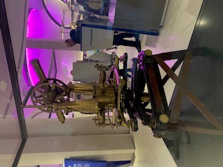
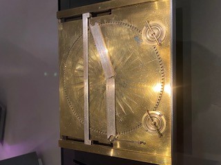
Then, in 1663, early surveyors made others surveyor's angle-measuring instrument but still used geometry with triangles because surveving is all about triangles. Indeed, in 1664, so that calculations involving triangles could be simplified, a machine named the trigonometry instrument was used by surveyors. It used a mathematical technique known as trigonometry and it enabled huge areas to be surveyed using the lengths and angles of triangles thanks too three rules which could be moved using dials to make a triangle of the required size where angles or lengths could then be read off directly. |
 |
 |
So, to conclude, surveying is one of the oldest mathematical practices, sharing features with navigation, gunnery and civil engineering. The mathematics involves measuring triangles. The results could mean the rise or fall of governments or even empires. And whatever is being surveyed - a building site, battlefield or entire country - the surveyor is building up a series of measurements of angles and lengths in triangles. Surveying remains a specialised and vital mathematical practice. Technologies such as satellites and laser ranging offer powerful new opportunities to increase the speed and precision of surveys. |